They asked of the cave's access point and whether geocaching (http://www.geocaching.com) was allowed. I showed them our boundary maps, and gave them access directions.
I also advised of our interest in establishing a trail head here from which caching parties could venture forth on their treasure hunts into the beautiful and rugged Ozark park.
They agreed to visit again soon, to send like minded parties, and to assist in this rewarding endeavor.
I also showed the photos of a new cave system I recently discovered here and agreed to take them there soon.
For photos of this cave (Crystal Cave) please click here.

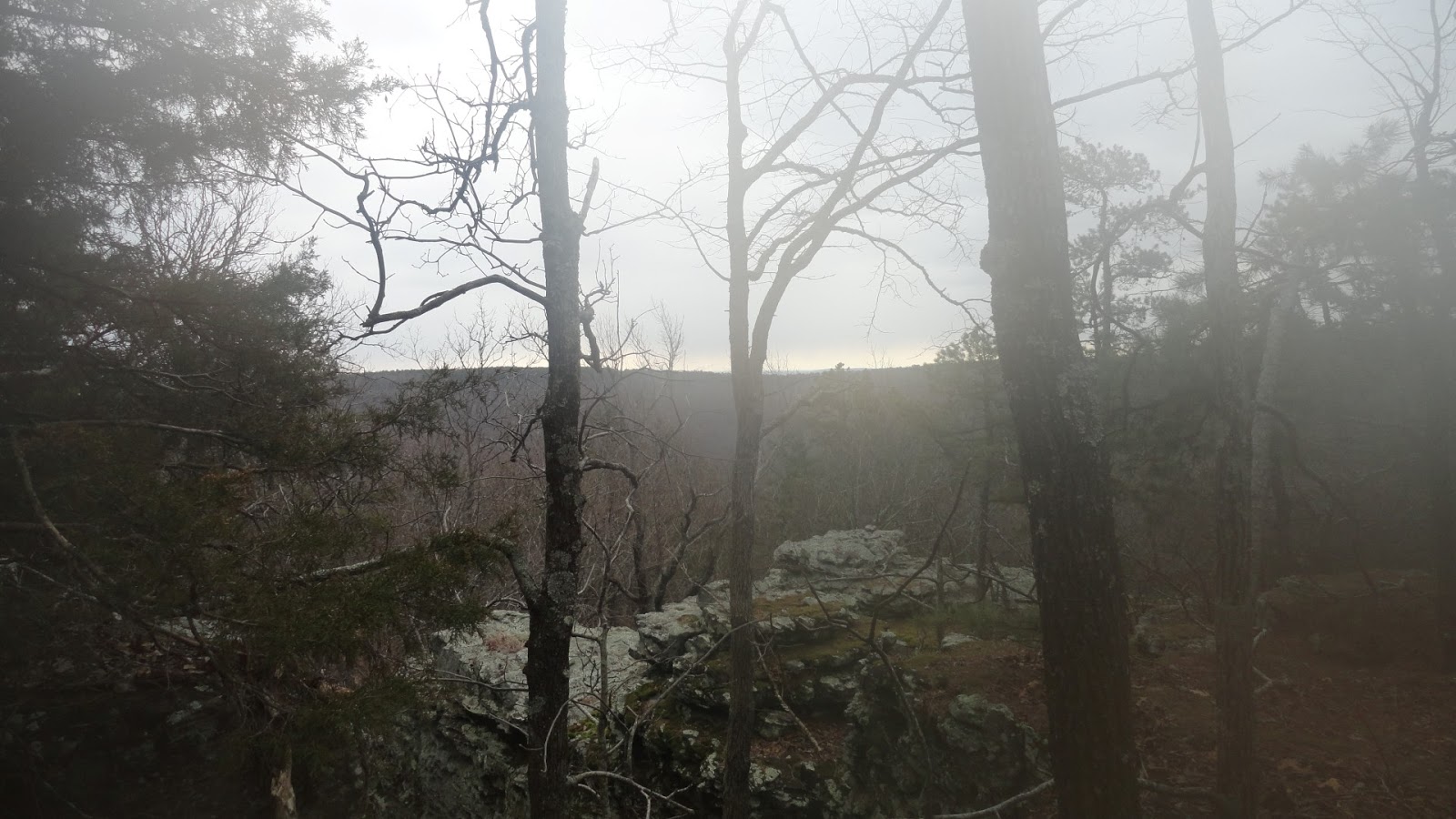
Today his dad Barry stopped by and introduced himself. As he looked at the vintage fly reels and rods on display we chatted about fishing and eventually discovered our mutual interest in hiking, topography maps, compasses, and GPS devices.
The gentlemen that accompanied Barry is from Illinois and added that he to enjoyed the hobby, saying that he even once had the privilege of officially naming a few landmarks for his native state. He travels to Arkansas regularly to mow and upkeep his Church's camp grounds.
This is where the idea of our trail system came in. The campground is a rural 25 acres and adjacent the Foushee WMA as our ten-acre homestead is. As the crow flies it is about a mile walk southeast of here and 1000 feet up.
Barry is a little new to digital maps so I will be assisting him online (I gave him a business card so he can find our page to communicate through initially). The groundsman also informed of the bluff system lining the camp and that it offers a great vista point of the valley below (this valley).
Now it is time to do a little mapping research online to see how the primary points may connect. Our vision is a shared digital map accessible to all of interest on which images will be embedded and way points added with Blue Fly as the trail head.
Until the envisioned map is created I will add links to webmaps that I am tinkering with as the dream unfolds.
Thanks again for sharing your time with us. More to come soon...
'Got the Topo
The mailman came to the front door with the 24"x30" topogragphy map in hand that I had ordered two weeks earlier. It arrived late but I am glad to have it.
Some fifteen years ago I learned of these map types while visiting random offices at the US Post Office in Batesville, AR. Back then they were $5.00 each. They are now $9.00. This I learned when visiting there last month to get one for this area shortly after Foushee WMA was opened to the public. Fortunately they were sold out and the handler was nice enough to give me the web address where they order from. I found mine for $6.95 base price, but after having it laminated and tubed it cost $12.80.
I intend to scan the relevant section of it, upload it to my new website via FTP (if I can) and offer it as a free download. I will link the choice here if successful.
In the meantime here is a webmap that I am working on of the area. You shouldn't need any extra software to view it (I had to install Silverlight to use the mapping program) but if a problem arises then please contact me and let me know of an issue. Also be mindful that the way points depicted are just guesstimates. We will edit it for accuracy once hiking season arrives and I get my first handheld (Garmin eTrex Legend HCx as recommended by Toby that placed the WMA boundary signs).
Also know that the WMA boundary line is a draft as we are still waiting the release of the digital shapefile.
The shape file has finally been released and is now attached to the above "webmap" link. \
Overseeing this natural area is the Arkansas Natural Heritage Commission. They have a great introductory page here: Arkansas Natural Heritage Commission.
Primitive Campground now open

Crystal Cave Tour
Saturday (2/2/13) customers from the market inquired of the Foushee WMA and its caves locations. I advised that on Sundays I give free tours.
The newlyweds arrived Sunday morning as promised and I led them to our nearby Crystal Cave. It was the gentleman' wife's first cave exploration and they had an excellent adventure.
As always it is a pleasure to help others enjoy the great outdoors. So anyone, anytime, stop by the Fly and we'll show you around.
As always it is a pleasure to help others enjoy the great outdoors. So anyone, anytime, stop by the Fly and we'll show you around.
Recent Hikes
Setting coordinates from the topo map we have been following bearings within the 240 deg. range and have discovered some very nice vista points from which we can see miles beyond our valley floor.
Consecutively for the previous three days we have been venturing four mile scouts on a round-about from and to the Fly.
Many deer and turkey here. Also fish are abundant in the nearby Foushee Lake to which we took the kids last weekend. For information and assistance concerning this natural area please stop in and inquire or send me an email at perrycalaway@gmail.com.
Until later I am booting up for a sunrise trail run into the rugged outback to enjoy the pleasures of God's great work.
More later. Please subscribe for updates.
Miles In The Morning
Over the last few weeks I have risen early and after sending the kids off to school, hiked south up Clark's Hollow to a height of approximate 900 feet (nice vista points all around, plenty of wild life and beautiful natural scenery).
Perhaps you can enjoy this area some day and if ever are inclined to do so will stop in or message me for helpful information.


Perhaps you can enjoy this area some day and if ever are inclined to do so will stop in or message me for helpful information.


Snow, A Mountain, Me and My two Daughters (ages Seven and Ten).
"Wanna take a hike kids?" I asked. "Yeah, yep, and let's go", they replied.
So from our homestead we headed up hill on a bearing of 165 degrees. Our destination: a half-acre pond approximately 900 feet above our valley's floor.
Due to the lack of shadows, fog, and a dense forest, I had to set way-points about every fifty feet to maintain our bearing.
The kids had a tough time climbing the mountain but we eventually reached our destination though took no time to enjoy the landmark as the girls were begging to head home. So I reversed the compass setting and followed it pinpoint to our property line.
"Wanna go again someday?" I asked. "Yep, they replied, "but not when it is snowing and cold."
I am regular visitor, how are you everybody? This post posted at this website
ReplyDeleteis really good.
Here is my page federal loans college
I was wondering if you ever considered changing the page layout of your website?
ReplyDeleteIts very well written; I love what youve got to say.
But maybe you could a little more in the way of content so people could
connect with it better. Youve got an awful lot of text for only having one or two images.
Maybe you could space it out better?
My web site private krankenversicherungen vergleichen
Thank you for the advise. I do agree that more images and content should be added.
DeleteWill do so soon.
Thanks for visiting.
Thank you friend for visiting and for your interest. I will certainly consider your advice.
ReplyDeleteThanks for reading.
Pretty! This has been a really wonderful post. Thanks for supplying this info.
ReplyDeletemy webpage - online jobs for stay at home moms
Thanks for the compliment!
DeleteWe have so much to learn and share of this natural area.
3000 acres is a lot to explore.
We will post more as our experience of the WMA evolves.
Dont try making it into some kind of tourist attraction, this land belongs to the locals of locust who grew up and hunted up on the mountain, not some passing through yankee.
Deleteoh yeah! your boundary map is wrong.
DeleteHello Dear, are you truly visiting this web page on a regular basis,
ReplyDeleteif so after that you will without doubt get good experience.
my web site: home equity loan refinance rates
I've been surfing on-line more than 3 hours today, but I by no means found any fascinating article like yours. It's beautiful price enough for me.
ReplyDeletePersonally, if all webmasters and bloggers made excellent content as you did,
the web will probably be a lot more useful than ever before.
My blog; best cheap hosting
Any turkeys up there? I'm not considered a local, but live in Salado...
ReplyDeleteTurkeys are out there. It's just rough hunting them. But I like the challenge
DeleteI'm a local that bow hunts off camp road. Has anyone noticed any small camp fires in the woods far off the beaten path as if someone is living out there? I also got game camera pics of a guy on a bicycle a 1/2 mile in the woods on the south side of the property and looks a Little creepy. I know it is illegal to stay the night out there and build fires and I don't want to walk up on someone before sunrise or after sunset that may be on drugs because anything could happen out there considering I carry a sidearm at all times when go out there. Any info would b greatly appreciated.
ReplyDeleteHow many caves are actually on the land? I am a local cave explorer and would like to do some treking in the off season. I have bow hunted the land many times but havent looked into exploring any caves, thought they were blocked off.
ReplyDeleteThank You and I have a neat supply: House Renovation What To Do First custom home remodeling
ReplyDelete